I took over 100 pictures on a helicopter trip out to Minna Bluff. It was STUNNING.
Don't worry, I only included my top 36 in this post (they took all night to upload..).
And, well, most of the 100+ pictures I took turned out very blurry. Taking pictures from a moving helicopter is quite difficult, if you can believe it. So my top 36 pictures might just happen to be the only non-blurry ones.
Quantity over quality, as I always say (when it comes to pictures).
Anyway. What was I doing at Minna Bluff? I went out with the AWS (Automatic Weather Stations) group again on Thursday to service one of their sites there.
 |
| Map of AWS stations. Minna Bluff is near the top; McMurdo is near the "Willie Field" marker. Source. Note: South is up on this map. |
I also finally found a map that has the whole area surrounding Ross Island. It's a USGS "Coastal-Change and Glaciological Map" that shows how the ice front has changed over time. Pretty cool! Also, it shows Ross Island and nearby islands. You can view it here.
Ok, and one more map. I love maps. This one is a closer view of Minna Bluff. Note that all the blue on this map is not, in fact, open ocean, but the Ross Ice Shelf. Covered in ice.
 |
| Minna Bluff in relation to Mt. Discovery, Black Island, and White Island. Ross Island is towards the north and off the top of this map. Source. |
Avi, Lee, Dave, and I loaded up the helicopter with the AWS cargo and climbed in the back. We flew in a larger helicopter this trip -- one of the two Bell 412's (hence why both Avi and I got to tag along this time).
 |
| All aboard the Bell 412! |
Passengers aren't allowed to sit in the front seat of the Bell 412's (unlike the smaller A-star that I got to ride up front in last week). Instead, our pilot (Eddie) was accompanied by a helitech (Clay) -- a helicopter technician there to assist.
 |
| Eddie the pilot (right) and Clay the helitech (left). The controls of the Bell 412 looked even more complicated than those in the A-star. |
 |
| Bye for now, McMurdo! |
I got some cool pictures on the flight over (well, about 1/3 of those pictures was cool. As we've been through already, the other 2/3 were unusably blurry.).
 |
| Helicopter shadow and ice cracking near the coast of Ross Island. There might be seals in this picture if you squint hard enough. |
 |
| White Island! With some cute cloud poofs. |
 |
| Another helicopter shadow picture, this time with Minna Hook in the background. |
 |
| The Bell 412 on Minna Bluff. |
Once we landed, the first order of business was to clean up some materials that were left at the site last season. The tower currently at Minna Bluff is maybe 8ft tall, held up with three guy wires. There used to be a taller tower, though, held up by lengths of chain buried into the ground. For extra safety, the chains were also attached to 5 wooden sleds, each covered in a pile of rocks to hold them steady even in high winds.
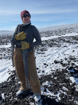
We made ourselves useful as heavy-lifters and carried the sleds and chains back to the helicopter. All the practice with batteries has paid off. 💪
 |
| Eddie and Avi carrying one of the wooden sleds to the helicopter. |
 |
| Here I am posing with one of the chains. Surprisingly, long lengths of metal chain are not light or easy to carry. |
While the rest of us lifted heavy stuff and put it back down, the AWS team got to work trouble shooting the station.
 |
| I took a picture of Dave taking a picture of the station. The AWS tower is on the right. I'll get into the double-solar paneled station in a bit. |
One of the immediately visible issues with this station was the buildup of some serious rime ice. Rime ice forms when supercooled water droplets (water below 0C), often from fog, freeze on contact with a below-freezing surface -- in this case, the AWS tower and equipment.
 |
| Rime ice on the AWS tower. The instruments (left to right): wind direction, temperature, antenna (with lots of rime), wind speed. |
Minna Bluff apparently has notoriously bad riming (rime icing?); Dave and Lee have seen the entire tower caked in rime ice, extending out over a foot.
 |
| I had some rime ice for a snack. It was a really weird texture to bite into. |
In addition to terrible rime ice, Minna Bluff also holds the official record for the highest recorded wind speed by AWS: 61 m/s (137 mi/hr). And keep in mind -- this is continuous wind speed. Not just a one-off gust. Yikes.
 |
| You can tell which direction the wind blows up here -- all the rocks had several inches of rime ice sticking out. |
Understandably, they have to use a super heavy-duty high wind speed sensor at this site. High wind speeds also rattle the tower around, leading to loose (or missing) bolts. There were several missing, including one in the solar panel attachment. That's part of the reason that they do regular maintenance on these sites (every 3 years-ish, barring COVID years) -- it's hard to engineer around 137mi/hr sustained wind speeds.
 |
| Lee tightening some cables in place. There's a bolt missing to the left of his hand. |
 |
| Lee replacing the solar panel mount (which had a missing bolt). |
Another problem at this site, not due to the crazy wind conditions, was the battery bank. Most AWS sites use two to three 100Ahr batteries (in comparison, PASSCAL sites typically use eight 108-129Ahr batteries). The batteries measured 3V each -- instead of the 13V they should be. Luckily, we had loaded three spare batteries in the helicopter. Avi and I lent a hand and carried them over.
 |
| Unloading the 200lb battery box from the helicopter. |
 |
| Picturesque old battery box with a cloud poof in the background. |
The last problem at this site was the antenna cable. The wind had shaken the cable around, and it had bent at the connector where it was held in place by the antenna. PASSCAL TO THE RESCUE! Avi and I had lent the AWS team a spare coax cable, and they were able to use it in place of the broken one!
 |
| Pretty sure these cables aren't supposed to bend like this.... |
 |
| You can see the PASSCAL Polar barcode on the AWS cable. Finally, we've contributed to science this season! |
The station right next to the AWS tower used to take air samples and measure air quality and ozone. The batteries have been dead for a while, apparently, and the scientists who installed it haven't come back to decommission the equipment yet.
 |
| Air quality station. The tubes are connected to a pump that takes air samples. |
While the AWS team did some troubleshooting, the rest of us took the opportunity to hike around. We had a great view of Minna Hook, the hook feature off the end of Minna Bluff (you can see it on the maps above!).
 |
| Me and Minna Hook. |
 |
| Looking towards Mt. Discovery (it's hidden by that hill). |
 |
| Me again! Black island is over my shoulder on the left and covered in an impressive-looking storm cloud. |
While we were walking around, we saw contrail from an LC-130 flying back from the South Pole station. And we could hear it, too!
 |
| LC-130 heading back from Pole to McMurdo! |
The helitech, Clay, started unpacking the survival bags from the helicopter and we all got a little anxious, worried they were going to take off and leave us. Turns out, he was just making a couch to take a nap on.
 |
| Clay taking a nap on the survival bags. |
Here are some more pictures I took while walking around.
 |
| Minna Hook, without me. |
 |
| The storm system over Black Island is getting progressively worse. |
 |
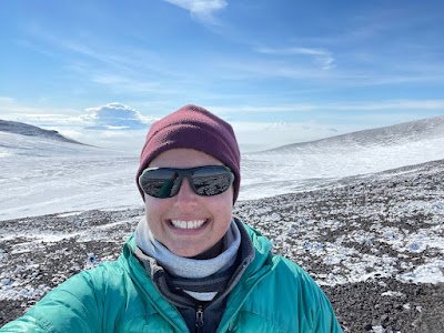
| Selfie! |
Once AWS had finished servicing their station, we all loaded back in the helicopter. Eddie circled around the site a few times and did a cool flyover down towards Minna Bluff.
 |
| Close-up view of the rocks on Minna Bluff. |
That's all for now! The rest of this post is just more pictures I took from the helicopter. Enjoy :)
 |
| Bye, Minna Bluff! |
 |
| Ice cracks (bonus Black Island in the background). |
 |
| Another helicopter shadow picture! |
 |
| Black Island and the spooky storm clouds! |
 |
| Ooh, aah. |
 |
| Look at those cool patterns in the rocks from the ice! |
 |
| More cool ice! |
Comments
May (Ella’s mom)